Sometimes when I go on a motorcycle ride, I go with some sort of a goal or destination in mind. Not always, of course, sometimes I just follow my front tire to wherever it leads me. On this day last September, my goal was to find a town limit sign for Jefferson Township, an unincorporated township from a bygone time at the southeastern most corner of Minnesota at the Iowa border. Technically, you could say there are five “corners” of Minnesota: Jefferson Township; Bruce MN, another small, probably difficult to find town in the southwest corner; Noyes, an old US/Canada border crossing in the northwest corner; Angle Inlet, the little spike at the very top of our state in which one must go into Canada to access by road; and finally, Grand Portage in the northeast corner. Over the years, I’ve motorcycled to Noyes, Angle Inlet, and Grand Portage. Each of these were easy to find even if, in the case of Angle Inlet, difficult to reach. Angle Inlet involves riding many miles of washboard sugar sand, which is very difficult to ride a road bike on. I last made that trip in approximately 1990, on a big touring bike, pulling a trailer full of camping gear no less. If I go back just for the sake of saying I went there twice, it will be on my Suzuki V Strom, a lighter, more worthy bike for off road adventures. But on this day, my search was for Jefferson Township.
My first stop was this small turnout structure on Hwy 26/Great River Rd just north of New Albin Iowa. It is no longer in use, whatever it is or was. There were no signs indicating its purpose, and there sure wasn’t anything saying it was in Jefferson Township.
A fountain or sink?
I rode past this building, then turned around about a half mile later hoping maybe it had been a train stop or the remnants to old “Jefferson Township” where I could find a township sign.
It turned out to be private property with a sign right at the railroad tracks advertising the privateness of said property followed by the words “NO TRESPASSING” in all caps. I always consider such signs a clue that the owner of the property doesn’t appreciate curious looky-loo’s exploring their property for any reason, and I respect those signs. There were no visible signs of Jefferson anywhere that I could see.
Continuing to explore, I chose to search the roads less travelled. They almost never disappoint for scenery and beauty even if they are somewhat lacking in the township signs department.
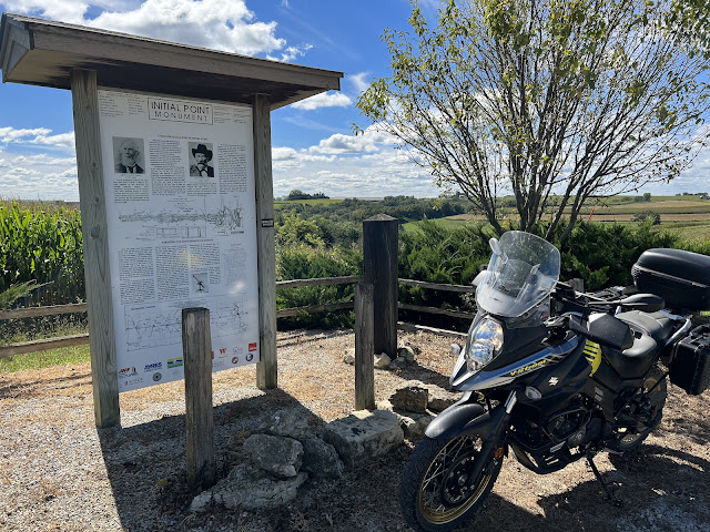
As I explored a road that weaved back and forth along the border, in and out of Iowa, I found this Initial Point monument. Placed here many years ago, this point, and another at the border at New Albin IA, were placed here as survey markers to assist in locating borders.
\
After seeing this cemetery sign, I kept riding nearly a mile while I contemplated whether I wanted to check it out. Ultimately, I turned around (yeah, I turn around A LOT) in hopes I might find some evidence of the elusive township of Jefferson. I mean, I enjoy the historical aspect of old cemeteries anyway, so it would be interesting to me at the very least. Besides, the road leading into the cemetery wasn’t really a “road”, and I love that.
The “road” into the cemetery. The photo doesn’t do justice to how steep and rutted this road is. Many of the ruts were concealed under leaves, and at one or two points along the ascent I considered that I may have bit off more than I could chew.
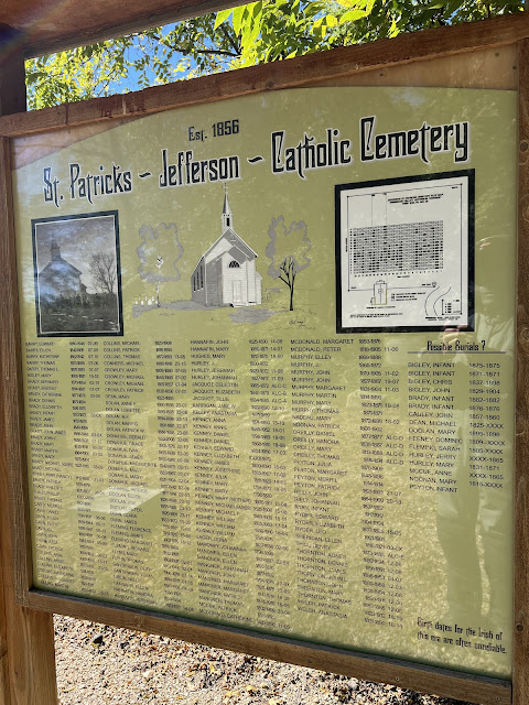
Fortunately, I made it to the top of the hill safe and sound. There are 391 grave sites in this cemetery, the vast majority being classified as “unknown” grave sites, those without any marker or record of who is buried there. Many of the existing grave stones indicate the county or town in Ireland where the person was born. Most of the people here were buried in the late 1800’s to early 1900’s, but there are a few more recent graves with markings from 2013 and 2008.
This sign, thus far my only sign showing Jefferson as a location, indicates that the cemetery was established in 1856. The land was formally purchased in 1868 for $10.00 and St. Patrick’s Church, a 30’ by 40’ building including a steeple and belfry, was built on this site. At the time, the congregation was made up of 25 families which eventually grew to 50 families. The people buried here are primarily Irish immigrants, and they held service at the church twice a month. The Catholic diocese closed the church in 1912, the year the Titanic sank, because of declining membership, and in 1916 the building was sold for $150 and dismantled. Portions of the foundation remain today. I couldn’t help but wonder if people who are buried here were related to or knew persons who had been on the Titanic.
The remains of the church foundation.
After my visit to St. Patrick’s cemetery, I explored several other roads, some of which were literally dead ends, but none resulted in a town sign. The silver lining of those dead end, difficult to turn around on roads, was there were no angry dogs guarding the farm yards these roads sometimes ended in. Why is it those dogs never seem to be happy-go-lucky golden retrievers rushing out to be petted?
I can honestly say I’ve searched high and low for evidence of Jefferson Township in this area, and while I haven’t yet found a town limit sign, I think I’ve satisfied my desire to document, at least in some way, that I made it to one of the five “corners” of Minnesota.
Thanks for looking at my photo blog!


