Welcome to one way I share my photography hobby and some of my travels. I hope you enjoy these photos and perhaps the story that accompanies them. Click on the photo to see a larger version.

Friday, June 24, 2022

A Three Day Adventure: Day 3

I woke up in Ely Minnesota, bright and early this morning.  My first stop would be in Chisholm, about an hour SW.

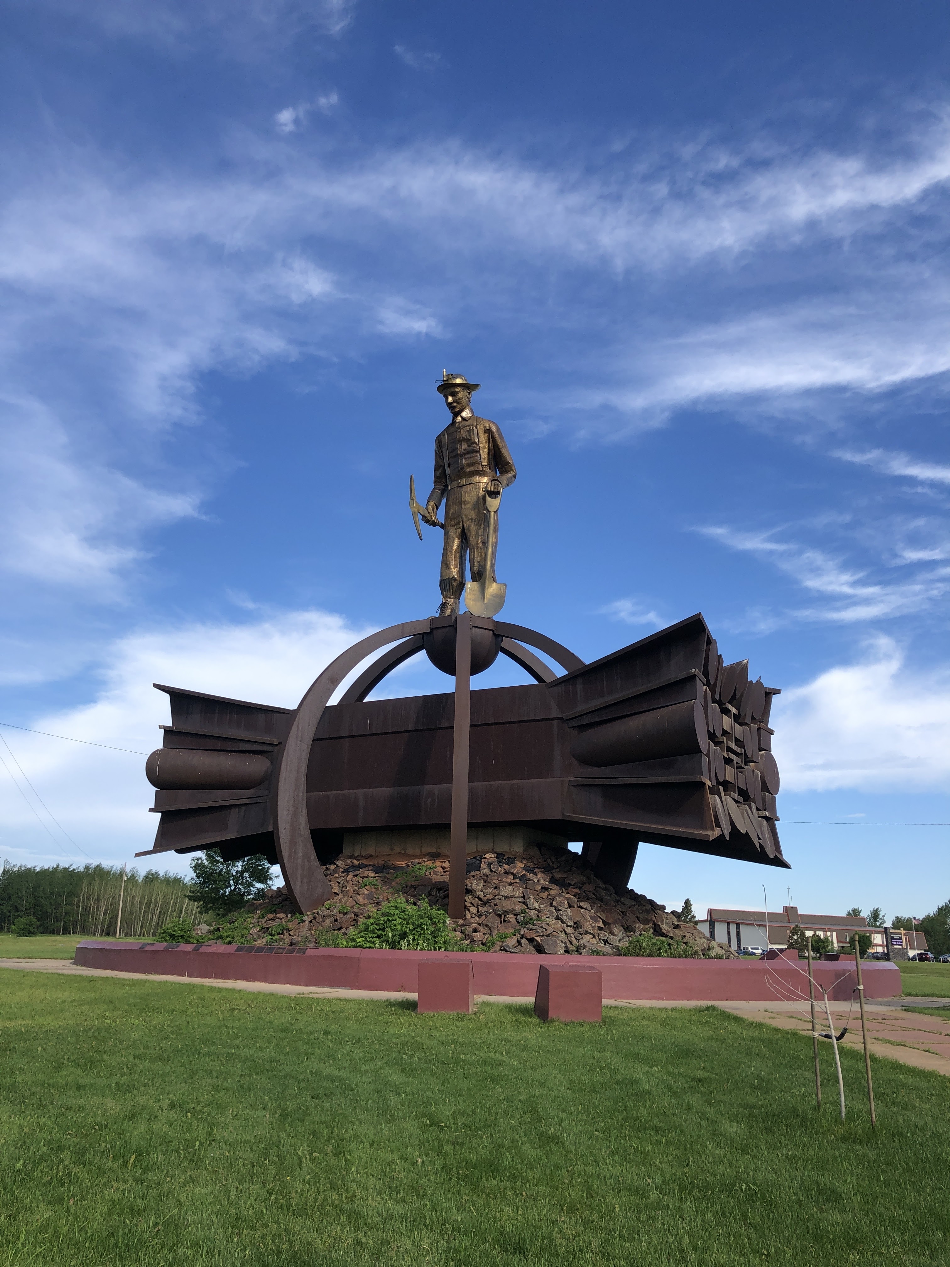
The Iron Men statue is the third largest free-standing memorial in the United States.  It is a memorial dedicated to the miners who, during the Industrial Age, “dug the mines and contributed to the building and expansion of this country”.  The memorial was built to honor the miners and keep the memory of their accomplishments alive while acknowledging that the Industrial Age is ebbing and the Technological Age is advancing.  


Prior to my three day adventure, I discovered that The Wall That Heals, a 3/4 scale replica of the Vietnam Veterans Memorial Wall in Washington D.C., would be in Chisholm when I was going to be in the area.  The Wall That Heals is a traveling memorial that is hauled around the United States by semi truck.  The wall itself is displayed here on a football field, and is made of a material that allows for etchings of names on paper, just like the wall in D.C.  The memorial also includes several displays on a semi trailer, including letters from soldiers, uniforms, and historical information about the Vietnam war.  There were numerous volunteers present, providing information and assisting people in finding the names of loved ones on the wall.


The displays in the trailer were very hard to photograph because they are behind plexiglass, so its very hard to read the text, but this display includes the helmet of a helicopter pilot who flew in-country in 1966-1967 and again in 1968-1969. I couldn’t help but think of my friend who also flew helicopter in Vietnam.  

“What was it like to serve in Vietnam”.  Several years ago, I sat down in a McDonald’s with another friend and a friend of his, both who had fought in Vietnam in 1966-1967, and listened as they told me what it was like.  Their stories have left a permanent mark on my soul, and I will never forget them.  


Some pretty staggering numbers here.

My next stop was, in my opinion, much less impactful, and it happened to be on my list of stops for the Grand Tour of Minnesota.  

Where it all started for Greyhound. In 1914, two people offered free test drives of this car in an attempt to sell this car.  It turned out that more people wanted rides as opposed to wanting to buy the car.  This spawned an idea: Charge people for rides.  From there, somehow, Greyhound bus services were created.

1927 Greyhound bus.

1936 Greyhound bus.

This Bull Eye on some 1947 Greyhound buses, dubbed the “Battle of Britain Design”, was put on buses to honor the Royal Air Force for its part in saving Britain from invasion by Germany. 


Lady Greyhound, the living trademark for Greyhound for many years.

An impressive collection of Greyhound bus models.  I think I may have had one of these when I was a kid.

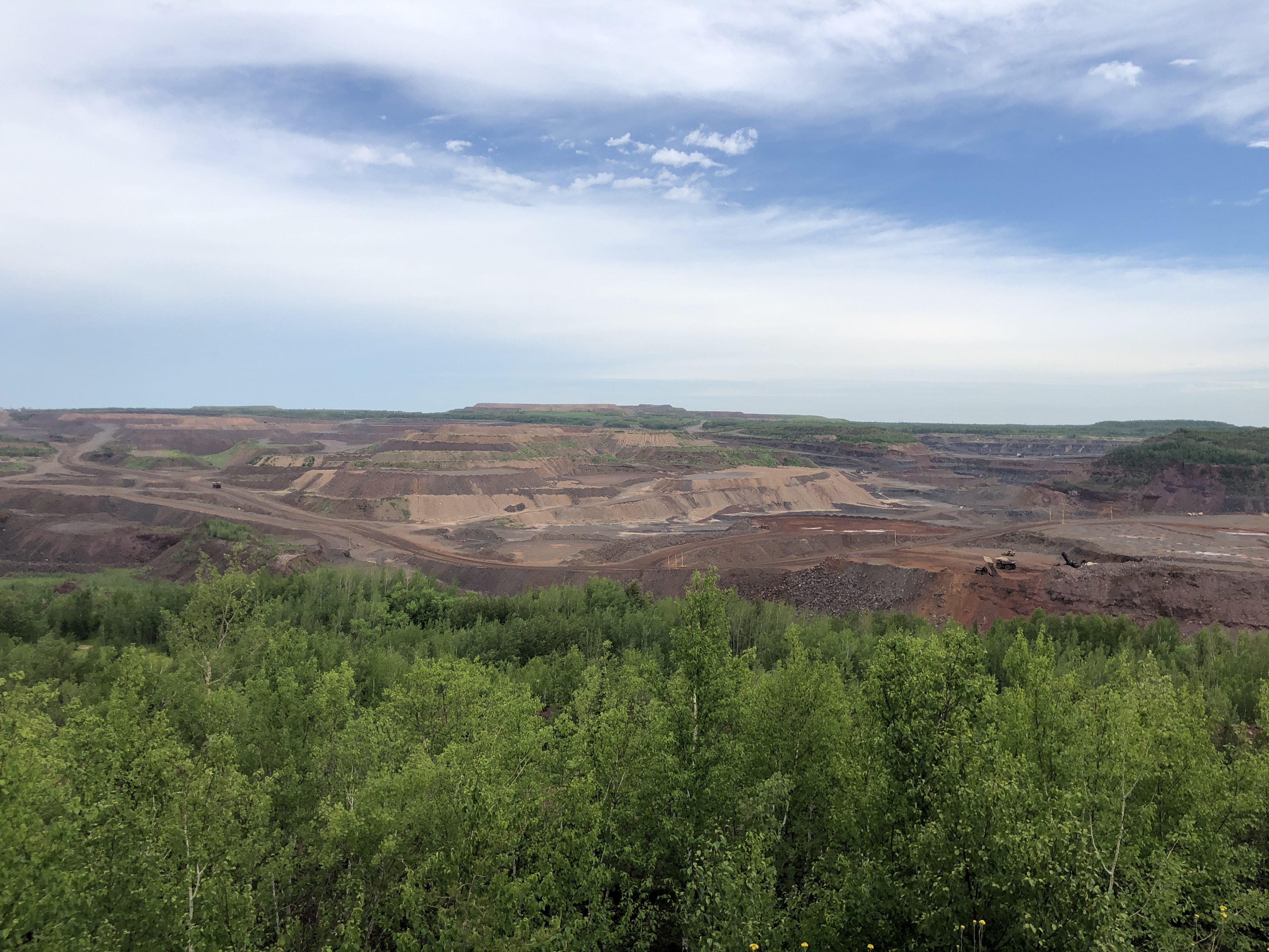
The Hull-Rust open pit iron mine in Hibbing.  While I was at the observation point here, I heard a couple of women talking to their kids about one of the dump trucks off in the distance.  “There’s daddy”, one of them said, so I asked if their husband or boyfriend worked in the pit.  Both women said “yes”, confirming that one woman’s husband was there and the other woman’s boyfriend was also working there.  Cool.

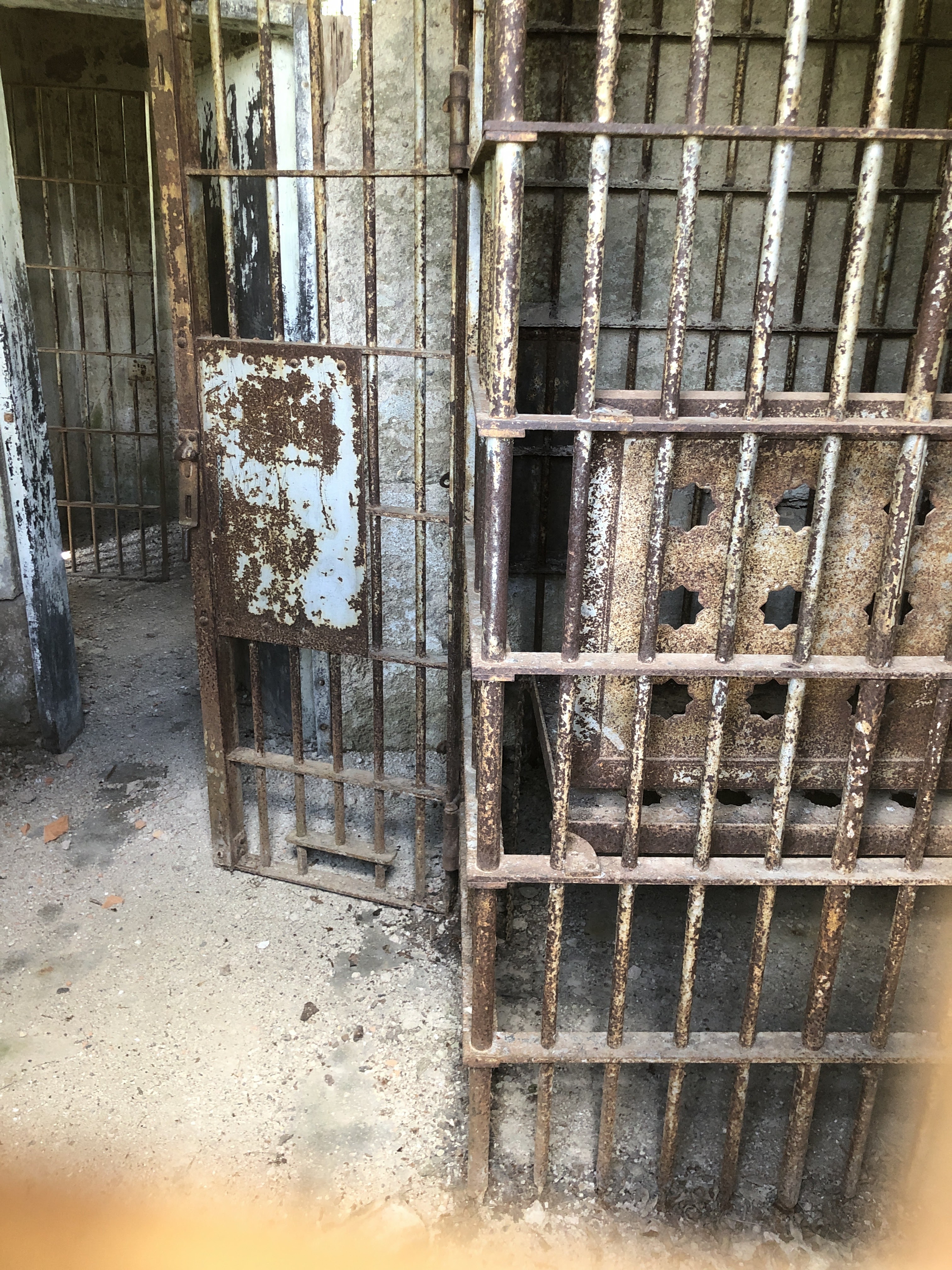
After Hibbing, I made my way south to an old school near Cromwell.  The building appears abandoned, but the grounds are still mowed.  It says “Eagle Lake School” in the wood above the entry, but I couldn’t find any historical information about this building.  My Sister-in-law, who lives in the area, said she’s talked to some people in the area who said it may also have been some sort of hospital or medical institution at some point.


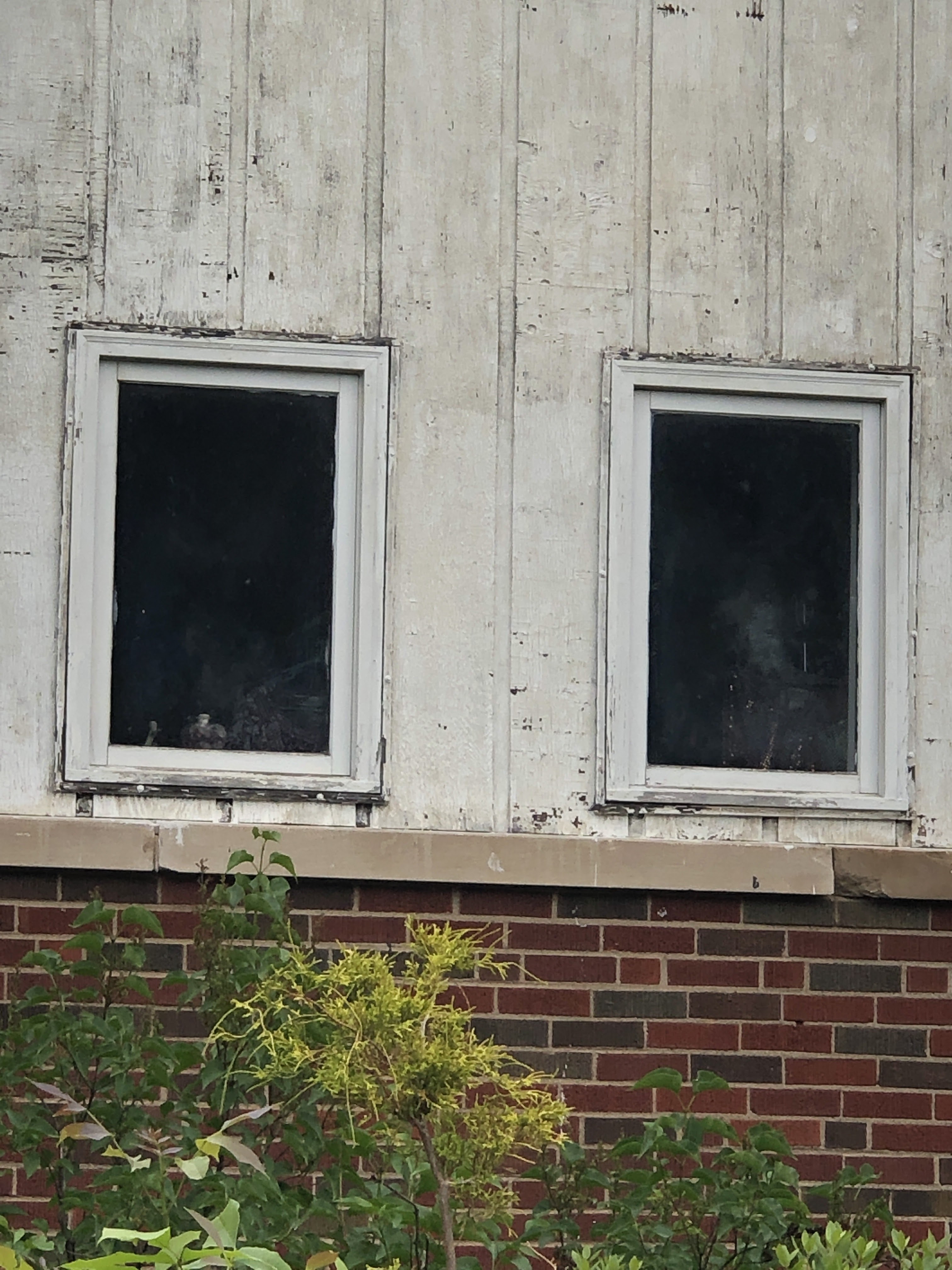
There appears to be clothing on racks visible through the windows.  Your guess is as good as mine here.

The steps were heavily worn in in need of repair.  As I walked up the steps I noticed a sign laying in the grass alongside the railing: “Private Property - No Trespassing”.  It was time to leave.

The grounds of Eagle Lake School. In disrepair, but mowed.  Somebody still owns the property.

I rode my motorcycle 950 miles during this three day adventure, experiencing temps from 55 degrees to 94 degrees, and meeting nice people along the way, including the relatively new owner of the motel in Ely, the server at the family restaurant in the otherwise sketchy city of Superior Wisconsin, and the sweet volunteer lady manning the counter at the Greyhound Bus Museum.  The beauty that surrounds us, whether it be abandoned or in nature, and the importance of remembering the good, the bad, and even the ugly, is not lost on me, even if those experiences are uncomfortable.  Life is a journey - or should I say an adventure.

Thanks for looking!  


Thursday, June 23, 2022

A Three Day Adventure: Day Two

 I woke up this morning to the low 70’s F in Superior Wisconsin.  A short time later, I was riding along the North Shore of Lake Superior and 55 degrees.  I set my sights on three Grand Tour of MN destinations for today: The Eagle Mountain Trailhead, the Trail’s End campground sign at the end of the Gunflint Trail, and The International Wolf Center in Ely.  Today involved riding over 300 miles, with a fair share of dirt/gravel forest roads purposely thrown in to make things interesting.  


My first stop on the North Shore to put additional layers on as the temp had dropped into the chilly zone.

All along the North Shore and along the Gunflint Trail are these beautiful Lupine.  

A trip up the North Shore wouldn’t be complete without a stop at Palisade Head.  

I would pause periodically to take in the beauty of the area, and then I would be swarmed with biting flies and mosquitoes as a bonus.


There’s road construction everywhere - even on a remote forest road near Eagle Mountain.  This “road work” turned out to be two stakes with orange ribbons marking an area on the side of the road that had been washed out, so it really wasn’t an inconvenience.

My official photo for the Grand Tour.  It was 89 degrees when this picture was taken.

I stopped in Grand Marais for much-needed gas, a gas station sandwich, and a couple stickers from the Lake Superior Trading Post.  It was 65 glorious degrees when this photo was taken.
From here, I rode SW down the North Shore until Hwy 1, which is a very nice, twisty and curvy, ride to Ely, where I visited the International Wolf Center for my final photo for the Grand Tour for the day.

The “thermostat” in my motel room in Ely because the AC for part of the building was broken.  Hopefully, remembering my North Shore ride today will keep me cool tonight.

Thanks for looking!


Wednesday, June 22, 2022

A Three Day Adventure: Day One

 Earlier this Spring, I signed up for the Grand Tour of MN, a motorcycle “event”, sort of, in which riders are to go to 20 locations in Minnesota chosen by the event organizers and take a picture of each location along with a booklet that has each riders identifying number and, preferably, the rider’s motorcycle. Today I set out to collect about 5 of those locations over the course of the next 3 days.  I decided to take a circuitous route and do some exploring that wouldn’t be related to the grand tour.  Here are some photos from day one.


My first stop was the Fresh Water Fishing Hall of Fame and Museum in Hayward Wisconsin. Built in 1978, it’s claim to fame is the giant Muskie sculpture, reportedly the world’s largest fish sculpture AND the world’s largest fiberglass structure.  The grounds also have four buildings which contain thousands of vintage lures, over a thousand antique boat motors, and 300 mounted fish. 

View from inside the giant Muskie’s mouth.


This outboard motor brought back memories of my Dad’s old Sea King 5 horse.


Leaving Hayward, I rode east to Clam Lake where I zig-zagged my way north through the Chequamegon-Nicolet National Forest via forest roads aka: dirt roads.  


Mason Wisconsin is considered the smallest incorporated village in Wisconsin.  Prior to being formally “established” in 1883 by the White River Lumber Company, it was inhabited by indigenous peoples. The lumber company’s mill burned to the ground in 1894.  When they rebuilt it, it was considered the largest lumber mill east of the Mississippi.  The mill was closed in 1913 and the area has been considered agricultural since 1914.  I just now noticed that the building says “Mason Hosue”…

Rush hour at the Mason Mall.

Wild flowers along a forest road.

Superior Wisconsin, where A World of Accordions Museum is located in an old church.  Unfortunately, their hours are very limited, and they were not open when I visited.  They also happen to be a place that teaches the repair and restoration of accordions.  There are a bunch of vintage accordions on display here. Perhaps I’ll see them on another occasion. 

A peak through the door into the museum.


Got my shot of the Aerial Lift Bridge in Duluth.  299 miles today.

Thanks for looking!


Friday, June 10, 2022

A Visit to Cosmos, a Boat Anchor, Glacial Remnants, and a Jail

Wednesday, I rode my motorcycle to Ortonville Minnesota in order to obtain a photo of Paul Bunyan’s boat anchor for a motorcycle Grand Tour I’m participating in.  I’ve been riding in similar Grand Tours for about 20 years, and they give riders an opportunity to go places and see things they may not normally have thought to go to.  This blog isn’t about the Grand Tour necessarily, but it is the reason I found other things featured in the blog that I think were interesting.

Cosmos Minnesota, where all the streets are given space-themed names, like planets, the names of astronauts, and constellations.  The water tower is in a park at the intersection of Venus St. E and Gemini Ave, a block away from Milkyway St. N.


Correll Minnesota, founded in 1881.  One of many small towns along the way.  This apparently is, or was, a fire hall.


A mural painted on the side of what appeared to be an abandoned building just outside of Ortonville.  I assure you, this is not at all representative of the skyline in Ortonville, and that’s not necessarily a bad thing.

THE reason I rode 200 miles to begin with: Paul Bunyan’s boat anchor.  According to legend and lore, Paul enjoyed fishing, and he is credited with making quite a few of Minnesota’s lakes.  Apparently, Paul really enjoyed fishing in nearby Big Stone Lake, Minnesota’s 10th largest lake, in part because of the size of fish here and also because it is here that he found a large enough stone to anchor his “mammoth boat”.  This granite stone anchor was placed in its current location, on the property of the Big Stone County Museum, on the eve of Minnesota’s statehood centennial in 1958.  After taking the photo, I went into the museum and chatted with Louise, a very nice person who grew up in Ortonville.  She joked that there are some who don’t believe Paul Bunyan ever existed.  I suggested that those people probably don’t believe in Santa, the Tooth Fairy, or the Great Pumpkin.  We laughed.  But I digress.

Ortonville is right on the border of South Dakota.  I had just ridden 200 miles, so I certainly wasn’t going to pass up an opportunity to cross into another state when it was so close.  Besides, it is at this very point where there is a dike and set of sluice gates at the south end of Big Stone Lake.  This point is considered the Headwaters of the Minnesota River which flows 318 miles to the confluence with the Mississippi River near Fort Snelling.


After visiting the Minnesota River Headwaters, I rode a few blocks more into South Dakota to Douthitt Park.  It’s claim to fame is that it is the lowest point in South Dakota, sitting at just 965’ above sea level.  Some of you might recall that I visited the “Center of the Nation” last year, located in Belle Fourche SD.  The exact location of the center of the nation is debatable, because there is another claim made that the actual center of the nation is in North Dakota.  So, to be fair to my friend Gundy, who proudly hails from North Dakota, I will point out here that North Dakota’s lowest point is 750’ above sea level, well over 100’ lower than SD yet still a far cry from the lowest point in the U.S.,  California’s Death Valley, which is located 282’ BELOW sea level.

After a fine bag lunch prepared for me by my lovely bride, I set out to find an historic jail located in Odessa Minnesota.  It is allegedly named after Odessa in the Ukraine.  People in the neighborhood waved back when I waved as I rode down the dusty dirt streets.
This is one of the dilapidated buildings in the very small town which consists of a small Main Street and several dirt streets that lead through very quiet neighborhoods. On Main Street, there is a bar/restaurant called the White Pony.  I pondered briefly if the proprietor at the White Pony answered the phone with, “It’s another beautiful day at the White Pony Cafe and continual soirĂ©e’” like Henry Standing Bear always answered the phone at the Red Pony Cafe in the Longmire series. Alas, the White Pony was not open during my visit, so perhaps we shall never know.

Ultimately, and thanks to the Google, I was able to find the old Odessa Village Jail, hidden away in a small park a couple dusty blocks off the main drag. Built in 1913, and finally condemned in 1945, this two cell jail served to house all “arrested persons” in Odessa, with the majority being inebriated or petty criminals.  When the village’s town hall was demolished in 1937, this jail became the oldest building in town. Imagine, this jail was in operation at a time, in 1933, when Bonnie Parker and Clyde Barrow were ranging as far north as Minnesota, robbing banks, such as the one in Okebena Minnesota, and small stores along the way.  I can find no historical information that Bonnie and Clyde came into Odessa, but it’s fascinating to me that this little non air-conditioned jail was functioning here during that period of our history.


I love photographing doors because they are portals in which countless people have walked through.  Imagine the people, both good and bad, that walked in through, and later out through, this door.

Emblem riveted to the door way back in 1913.

The windows were/are protected by a layer of hardened bars and another layer of steel mesh.

Two courses of brick plus an inner wall of cement make the walls a lot of work to break into or out of.

The main door was chained and locked.  I took this as a clue that someone did not want people to enter the actual jail.  Having no intentions of seeing what the inside of the current Big Stone County Jail looks like, I took my photos by aligning the lens on my phone’s camera with a hole in the steel mesh and hoping for the best while also hoping I didn’t drop my phone into the cell through a gap in the brick.  That could have presented a quandary for me…


The cell does not appear to lend itself to a good night’s sleep.


11,000 years ago, the last glacier to retreat across Minnesota created this valley in which the Minnesota River flows.

Facing east, and the 200 mile ride home.

Thanks for looking!

Followers